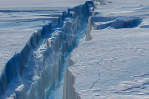
 Image Credit: NASA |
|
The crack happened in October 2011, and scientists think that part of the glacier will break off and become an enormous iceberg – though they aren’t exactly sure when it will happen.
In October 2011, researchers flying in NASA’s Operation IceBridge campaign made the first-ever detailed, airborne measurements of a major iceberg calving event while it was in progress. The above image is a still frame captured from a three-dimensional, virtual flight through the new rift in the Pine Island Glacier.
Four months later, the IceBridge team has mapped the crack in Antarctica’s Pine Island Glacier in a way that allows glaciologists and the rest of us to fly through the icy canyon. The animation (below) was created by draping aerial photographs from the Digital Mapping System—a still camera with very precise geolocation ability—over data from the Airborne Topographic Mapper—a scanning laser altimeter that measures changes in the surface elevation of the ice.
The world is changing.

No comments:
Post a Comment